Tidal marshes provide a range of ecosystem services, including carbon sequestration. Although New Jersey’s tidal marshes appear to have kept pace with historical sea level rise in the pre-industrial period (Kemp et al., 2013), accelerating rates of sea level rise (Sweet et al., 2017) coupled with land-use changes (Lathrop et al., 2014) and sediment starvation (Peteet et al., 2018) may limit their resilience to future sea level rise. Potential future marsh loss may contribute not only to the loss of the habitat and flood protection they provide, but also to the release of their stored carbon. To identify areas where targeted conservation or restoration efforts would be most beneficial for preserving ecosystem services of marshes, it is important to (a) predict future marsh response to sea level rise (SLR) and (b) quantify their ecosystem services, such as their potential carbon storage. Currently, data on accretion and surface elevation change is lacking for tidal marshes of the Raritan River and Bay, as are estimates of the carbon stored in tidal marshes (i.e., blue carbon) in this region (e.g., see CCRCN database, https://serc.si.edu/coastalcarbon/data).
To address these knowledge gaps, the project team (Laura Reynolds, Julie Blum, Richard Lathrop, Jennifer Walker, Kristen Joyse, Margaret Christie) proposed to use sediment core analyses to measure decadal-centennial accretion rates and carbon sequestration in the tidal marshes along the Raritan River and Bay to improve models of future marsh response to sea level rise. To accomplish these goals, with the help of six undergraduate students and several graduate students and postdocs, we collected 20 sediment cores that reached 1-8 m below the marsh surface from three sites (Figure 1) along the Raritan River and Bay.
Cores were collected in 50 cm overlapping segments with a Russian Peat Corer. Cores were visually described and sampled at 1-10 cm resolution for organic carbon content and Pb-210 and Cs-137 analyses. We dried 1 cm3 of sediment for 12 h at 105 oC to determine the dry bulk density, and then heated the sample to 550 oC for 4 h to measure the organic content (Loss on Ignition, LOI). The LOI values were converted to g C cm-3 using established relationships (Craft, 1991; Holmquist et al., 2018) (Figure 2).
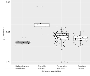 We find that the average organic carbon content for the 800 samples measured thus far is comparable between sites, with an overall average value of 0.033 (sd = 0.012) gC cm-3, which is similar to the average calculated for a recent national inventory (0.027 gC cm-3, sd = 0.013, Holmquist et al., 2018). The organic content appears to decrease with depth (Figure 2). In addition, preliminary data suggests the carbon content of the upper 50 cm of sediment varies among areas of different dominant vegetation (Figure 3), although additional data is needed to determine the extent of this variation.
Future work will focus on using forthcoming Pb/Cs and 14C data to determine long-term rates of accretion in these tidal marshes, as well as how carbon sequestration has varied through time. In sum, the results of this project will help quantify rates of accretion and carbon sequestration in Raritan tidal marshes, information that will aid projections of future marsh ecosystem services.
This effort was supported by a 2019 Rutgers Raritan River Consortium (R3C) Mini-grant to support research and student engagement on Raritan River, basin and bay resources issues. You can find more information about the R3C mini-grants here.
For more information about this effort, contact Dr. Laura Reynolds, Postdoctoral Associate, Institute of Earth, Ocean, and Atmospheric Sciences (EOAS), School of Environmental and Biological Sciences. Figures provided by Dr. Laura Reynolds.
Read Carol Peters’ (EOAS) article on this research: How Are the Raritan River and Bay Adapting to Sea Level Rise?
Citations
Craft, C. B., Seneca, E. D., & Broome, S. W. (1991). Loss on ignition and Kjeldahl digestion for estimating organic carbon and total nitrogen in estuarine marsh soils: calibration with dry combustion. Estuaries, 14(2), 175-179.
Holmquist, J. R., Windham-Myers, L., Bliss, N., Crooks, S., Morris, J. T., Megonigal, J. P., … & Ferner, M. C. (2018). Accuracy and precision of tidal wetland soil carbon mapping in the conterminous United States. Scientific reports, 8(1), 1-16.
Kemp, A. C., Horton, B. P., Vane, C. H., Bernhardt, C. E., Corbett, D. R., Engelhart, S. E., … & Cahill, N. (2013). Sea-level change during the last 2500 years in New Jersey, USA. Quaternary Science Reviews, 81, 90-104.
Lathrop, R., Auermuller, L., Trimble, J., & Bognar, J. (2014). The application of WebGIS tools for visualizing coastal flooding vulnerability and planning for resiliency: The New Jersey experience. ISPRS International Journal of Geo-Information, 3(2), 408-429.
Peteet, D. M., Nichols, J., Kenna, T., Chang, C., Browne, J., Reza, M., … & Stern-Protz, S. (2018). Sediment starvation destroys New York City marshes’ resistance to sea level rise. Proceedings of the National Academy of Sciences, 115(41), 10281-10286.
Sweet, W. V., Kopp, R. E., Weaver, C. P., Obeysekera, J., Horton, R. M., Thieler, E. R., & Zervas, C. (2017). Global and regional sea level rise scenarios for the United States.