The changing climate and development patterns of the Lower Raritan Watershed occur against a backdrop of substantial impervious surface coverage (approximately 34%), high population density, and significantly modified stream networks (e.g., stream straightening and burial, culverts, underground retention). Through hundreds of years of anthropogenic influence, the historic stream channels have been altered or “disappeared,” resulting in increased flooding, compromised water quality, and decreases in aquatic and other species. The added influence of climate change heightens these impacts. In addition, many Lower Raritan Watershed municipalities have no way to understand the lost natural and cultural heritage represented by the historic hydrology, the failing underground infrastructure and the collapse of buried streams.
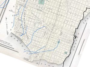
Figure 2 – An 1872 map of Perth Amboy overlaid with linework (in blue) showing potential streams from other map sources.
The research is intended to develop a systematic approach to define, identify, and describe the progression of the geographic pattern of “hidden” and “dynamic” streams in the Lower Raritan Watershed — that is, those areas that no longer exhibit all of their surface stream channels due to the effects of human development and population growth. It will allow for creation of an organized system for relevant stream and hydrology maps and map downloads to assist in “finding” the lost and hidden waterways in our watershed. This research is important as a way to understand our historic ecology and also to inform efforts that seek to use stream daylighting as a form of Green Infrastructure for stormwater management, water infrastructure management, and water quality improvements in our urban communities. Sharing the resulting data and materials will represent a first step towards the creation of a comprehensive data clearinghouse for the communities of this landscape.
As it progressed, the project included Dr. David Tulloch (Landscape Architecture, GeoHealth Lab at the Center for Remote Sensing and Spatial Analysis (CRSSA)) and Dr. Heather Fenyk (of the Lower Raritan Watershed Partnership) as leaders, undergraduate student Colin Marx, and GIS technician Brenda Allen.
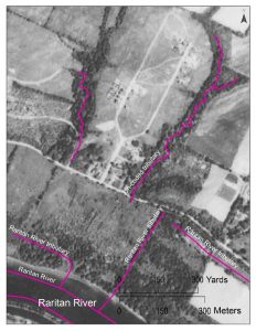
Figure 3 – This early 1930s black and white aerial photography of Piscataway shows the early development of Ross Hall Blvd and parts of what is now the Rutgers Ecopreserve. The fuscia linework shows the current NHD stream dataset that was used for comparison in the project.
This project captures the Raritan River’s lost heritage by creating new data while making existing records more widely available and used. This ongoing research endeavors to define, identify, and describe the progression of the geographic pattern of “hidden” and “forgotten” streams in the Lower Raritan Watershed — that is, those areas that no longer exhibit all of their surface stream channels due to the effects of human development and population growth. This research helps us understand our historic ecology and also can inform future efforts that seek to use stream daylighting as a form of Green Infrastructure for stormwater management, water infrastructure management, and water quality improvements in our urban communities.
Initial outcomes included:
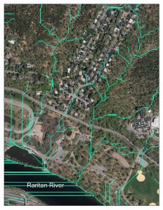
Figure 4- A recent color photo of the same area in Piscataway overlain with the GIS-generated linework (in green) showing terrain-based analysis of potential drainage and stream patterns.
- Created a research catalog linking to 40 sites with potential materials for ongoing evaluation and inclusion
- Evaluated materials at 22 of those sites
- Catalogued 230 maps to evaluate
- Developed 41 sharable georectified version of historic maps
- Identified over 2000 line segments on the historic maps that do not closely match those in the contemporary stream data
- Created an online site at https://crssa.rutgers.edu/projects/RaritanHistory/
The GeoHealth Lab at the CRSSA and the LRWP intend to supplement the ongoing project with volunteers while seeking additional funding in order to continue, (a) acquiring, compiling, and georectifying historic maps, (b) expanding and improving the project website, and (c) field check sites to determine the streams’ status.
For more information, contact David Tulloch, Center for Remote Sensing and Spatial Analysis, tulloch@crssa.rutgers.edu. This project received support from a 2019 Rutgers Raritan River Consortium (R3C) mini-grant.